Geolocate

Julian topographic map

Click on the map to display elevation.

About this map

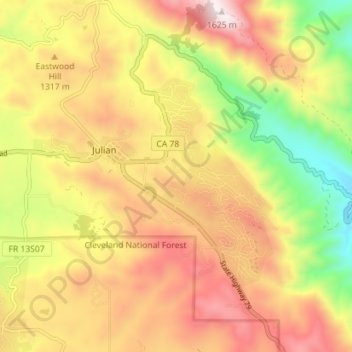
Name: Julian topographic map, elevation, terrain.

Location: Julian, San Diego County, California, 92038, United States (33.04449 -116.62251 33.10344 -116.55164)

Average elevation: 1,259 m

Minimum elevation: 843 m

Maximum elevation: 1,626 m

Other topographic maps

Click on a map to view its topography, its elevation and its terrain.

Julian

United States > California > San Diego County > Julian

Average elevation: 1,259 m

Gear up for your next adventure:

🪑Portable Backpacking Chairs - A comfortable seat for studying maps at the end of the day
🪢Paracord - Multi-purpose survival cord
🧳Outdoor Travel Organizers - Gear organization accessories
🔪Outdoor Multi-tools - Versatile tools for gear repair and survival tasks in the wilderness
📡Portable Emergency Radios - Stay informed about weather warnings and bushfire alerts

As an Amazon Associate, this site earns from qualifying purchases at no extra cost to you.