
Kailua-Kona topographic map
Interactive map
Click on the map to display elevation.
About this map
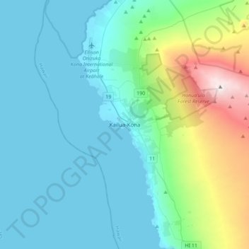
Name: Kailua-Kona topographic map, elevation, terrain.
Location: Kailua-Kona, Hawaiʻi County, Hawaii, 96840, United States (19.60194 -156.03693 19.68194 -155.95693)
Average elevation: 100 m
Minimum elevation: 0 m
Maximum elevation: 662 m
Other topographic maps
Click on a map to view its topography, its elevation and its terrain.
Mauna Kea
United States > Hawaii > Hawaiʻi County
Mauna Kea, Hawaiʻi County, Hawaii, United States
Average elevation: 3,978 m
Kīlauea
United States > Hawaii > Hawaiʻi County
Kīlauea, Hawaiʻi County, Hawaii, 96718, United States
Average elevation: 1,096 m