
Mauna Kea topographic map
Interactive map
Click on the map to display elevation.
About this map
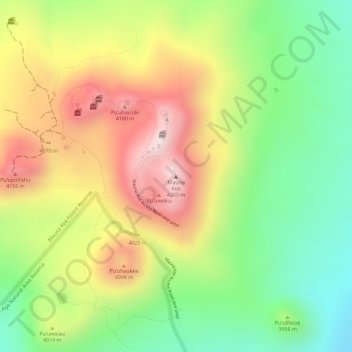
Name: Mauna Kea topographic map, elevation, terrain.
Location: Mauna Kea, Hawaiʻi County, Hawaii, United States (19.82062 -155.46812 19.82072 -155.46802)
Average elevation: 3,978 m
Minimum elevation: 3,759 m
Maximum elevation: 4,209 m
Mauna Kea (/ˌmɔːnə ˈkeɪə/ or /ˌmaʊnə ˈkeɪə/; Hawaiian: [ˈmɐwnə ˈkɛə]; abbreviation for Mauna a Wākea) is an inactive volcano on the island of Hawaiʻi. Its peak is 4,207.3 m (13,803 ft) above sea level, making it the highest point in the state of Hawaii and second-highest peak of an island on Earth. The peak is about 38 m (125 ft) higher than Mauna Loa, its more massive neighbor. Mauna Kea is unusually topographically prominent for its height: its wet prominence is fifteenth in the world among mountains, at 4,205 m (13,796 ft); its dry prominence is 9,330 m (30,610 ft). This dry prominence is greater than Mount Everest's height above sea level of 8,848.86 m (29,032 ft), and some authorities have labeled Mauna Kea the tallest mountain in the world, from its underwater base. Mauna Kea is ranked 8th by topographic isolation.
Other topographic maps
Click on a map to view its topography, its elevation and its terrain.
Kailua-Kona
United States > Hawaii > Hawaiʻi County
Kailua-Kona, Hawaiʻi County, Hawaii, 96840, United States
Average elevation: 100 m
Kīlauea
United States > Hawaii > Hawaiʻi County
Kīlauea, Hawaiʻi County, Hawaii, 96718, United States
Average elevation: 1,096 m