
Halverscheid topographic map
Interactive map
Click on the map to display elevation.
Halverscheid
Ahe | Altemühle | Anschlag | Auf dem Heede | Auf dem Wiebusch | Auf den Eicken | Auf den Kuhlen | Auf der Bever | Auf der Brake | Auf der Mark | Bärendahl | Beisen | Beiserohl | Becke | Berge | Bergfeld | Berken | Birkenbaum | Bochen | Bocherplatz | Bommert | Borkshof | Brenscheid | Brocksiepen | Bruch | Brüninghausen | Büchen | Büchenbaum | Büchermühle | Burbach | Burg | Buschhauser Hammer | Carthausen | Collenberg | Clev | Dahlhausen | Dicksiepen | Diekerhof | Dienstühlen | Dommelnheide | Dornbach | Dörnen | Edelkirchen | Ehberg | Ehringhausen | Eichhofermühle | Eichholz | Eickerhöhe | Eickerschmitte | Engstfeld | Eschen | Eversberge | Felsenberg | Gehärte | Gesenberg | Giersiepen | Glörfeld | Grafweg | Grund | Grünenbaum | Grünewald | Hagebüchen | Hagebücherhöh | Hagedorn | Hakenberg | Halloh | Halverscheid | Handweiser | Hartmecke | Heide | Heerenfelde | Heesfeld | Heesfelder Hammer | Heesfelder Mühle | Hefendehl | Heinken-Hedfeld | Herweger Schleifkotten | Hesseln | Hinterhedfeld | Hohenplanken | Hohl | Holte | Howarde | Hulvershorn | Husen | Im Heede | Im Sumpf | Im Wiebusch | In den Eicken | In den Kuhlen | In der Hälver | Kamscheid | Kirchlöh | Kotten | Krause Buche | Kreimendahl | Kreisch | Kreuzweg | Kückelhausen | Landwehr | Lausberge | Lingen | Lingensiepen | Löhbach | Löhrmühle | Lömmelscheid | Magdheide | Mark | Mesenhohl | Mittelcarthausen | Mittelherweg | Niederbolsenbach | Niederbommert | Niederbuschhausen | Niederennepe | Niederhedfeld | Niederherweg | Niederhövel | Niederhürxtal | Niederlangenscheid | Niedervahlefeld | Neuenhaus | Neuenherweg | Neuenvahlefeld | Nonnenennepe | Nordeler Schleifkotten | Nordeln | Oberbolsenbach | Oberbommert | Oberbrügge | Oberbuschhausen | Obercarthausen | Oberherweg | Oberhövel | Oberhürxtal | Oberlangenscheid | Obervahlefeld | Oeckinghausen | Oege | Oesterberg | Ohl | Osenberg/Osenbergermühle | Ostendorf | Othmaringhausen | Pottheinrich | Rothenbruch | Schanzmannsmühle | Schlachtenrade | Schlade | Schlechtenbach | Schlemme | Schmalenbach | Schmidthausen | Schmidtsiepen | Schneehohl | Schöneberge | Schröders Herweg | Schüreichhofen | Schulten Hedfeld | Schwarzenbach | Schwenke | Siepen | Solberg | Sondern | Steinbach | Stenkenberg | Sticht | Stichterweide | Stieneichhofen | Stöcken | Streitstück | Sundern | Vahlefelderheide | Vömmelbach | Volme | Vormbaum | Vorst | Voswinkel | Walde | Wegerhof | Weißenpferd | Wiebusch-Hedfeld | Wiene | Wilhelmshöh | Winkhof | Wöste Abgegangene Ortschaften und Wohnplätze Auf dem Pütte | Bocklenberg | Brake | Dahlhauser Schleifkotten | Ehringhauser Heide | Ennepe | Niederhersbach | Karbecke | Kerspe | Kersper Brücke | Klotzhütte | Niederplanken | Oberennepe | Oberhersbach | Springmannshof | Sträters Häuschen | Wegerbuch
About this map
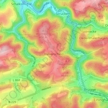
Name: Halverscheid topographic map, elevation, terrain.
Average elevation: 328 m
Minimum elevation: 218 m
Maximum elevation: 432 m