
Hösinghausen topographic map
Interactive map
Click on the map to display elevation.
About this map
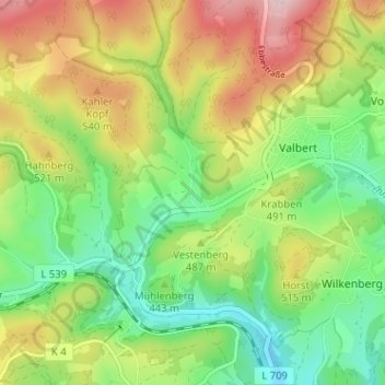
Name: Hösinghausen topographic map, elevation, terrain.
Average elevation: 471 m
Minimum elevation: 361 m
Maximum elevation: 629 m
Other topographic maps
Click on a map to view its topography, its elevation and its terrain.
Höh
Deutschland > Nordrhein-Westfalen > Märkischer Kreis > Meinerzhagen > Valbert
Höh, Valbert, Meinerzhagen, Märkischer Kreis, Nordrhein-Westfalen, Deutschland
Average elevation: 452 m