Geolocate

Mason topographic map

Click on the map to display elevation.

About this map

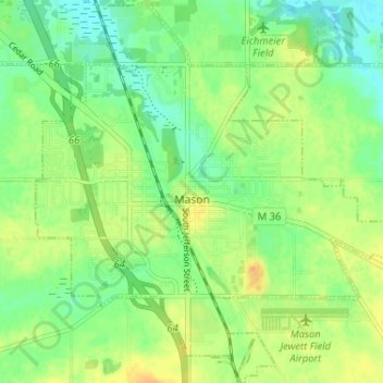
Name: Mason topographic map, elevation, terrain.

Location: Mason, Ingham County, Michigan, 48854, United States (42.55681 -84.46874 42.60444 -84.40694)

Average elevation: 276 m

Minimum elevation: 262 m

Maximum elevation: 292 m

Gear up for your next adventure:

📸Action Cameras - Record your journey across interesting topographic features in 4K
🚁Camera Drones with GPS - Capture aerial views of the landscape to compare with topo maps
🔋Solar Power Banks - Solar chargers for outdoors
🦯Adjustable Trekking Poles - Reduce impact on knees when descending steep topographic ridges
🪑Portable Backpacking Chairs - A comfortable seat for studying maps at the end of the day

As an Amazon Associate, this site earns from qualifying purchases at no extra cost to you.