

Batroun topographic map
Click on the map to display elevation.
About this map
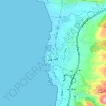
Name: Batroun topographic map, elevation, terrain.
Location: Batroun, Batroun District, North Governorate, 1400, Lebanon (34.24044 35.65548 34.27286 35.68647)
Average elevation: 31 m
Minimum elevation: 0 m
Maximum elevation: 262 m
Other topographic maps
Click on a map to view its topography, its elevation and its terrain.
Mount Lebanon
Mount Lebanon (Arabic: جَبَل لُبْنَان, jabal lubnān, Levantine Arabic pronunciation: [ˈʒabal lɪbˈneːn]; Syriac: ܛܘܪ ܠܒ݂ܢܢ, ṭūr leḇnān, Syriac pronunciation: [tˤur lewˈnɔn], ṭūr lewnōn) is a mountain range in Lebanon. It averages above 2,500 m (8,200 ft) in elevation, with its peak at 3,088 m (10,131 ft).
Average elevation: 2,819 m
Aitou
With a Qaf (Qaitou), the name in Aramaic could mean summer, heat or boar. It is equivalent to the Arabic Qaiz (قيظ), meaning canicule or heat wave. It could refer to Aitou being used as a Summer Resort given the town's location at a high elevation, yet only 27 km from the Mediterranean coast.
Average elevation: 873 m