Geolocate

Featherston Community topographic map

Click on the map to display elevation.

About this map

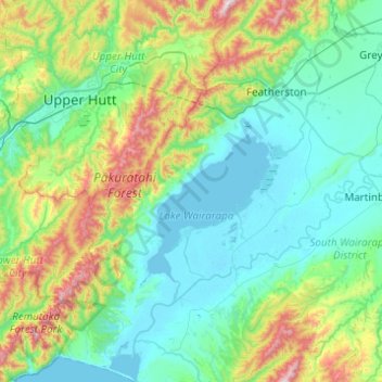
Name: Featherston Community topographic map, elevation, terrain.

Location: Featherston Community, South Wairarapa District, Wellington, New Zealand (-41.39726 174.95865 -41.02795 175.37803)

Average elevation: 216 m

Minimum elevation: -4 m

Maximum elevation: 1,005 m

Other topographic maps

Click on a map to view its topography, its elevation and its terrain.

Gear up for your next adventure:

🧯Animal Deterrent Spray - Safety spray for wildlife
🦯Adjustable Trekking Poles - Reduce impact on knees when descending steep topographic ridges
🔭Compact Hiking Binoculars - Lightweight optics for scouting routes or birdwatching
📕Australia Maps - Maps covering Australian regions
🧭Compass - Navigation compasses for outdoor exploration

As an Amazon Associate, this site earns from qualifying purchases at no extra cost to you.