Geolocate

Gasan topographic map

Click on the map to display elevation.

About this map

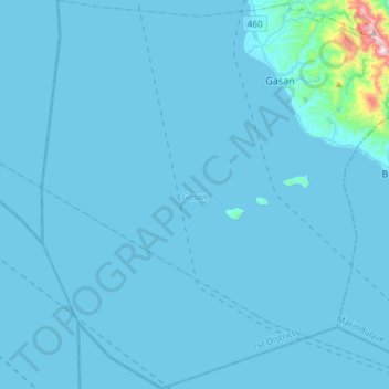
Name: Gasan topographic map, elevation, terrain.

Location: Gasan, 1st District, Marinduque, Mimaropa, 4905, Philippines (13.09527 121.66473 13.38345 121.95896)

Average elevation: 56 m

Minimum elevation: 0 m

Maximum elevation: 800 m

Gear up for your next adventure:

🥤Hydration Packs - Hydration systems for hiking
🎒Dry Bags - Waterproof bags for outdoor gear
🥶Thermal Beanies - Warm hats for cold hikes
📟Satellite Messengers - Two-way satellite communication to stay in touch beyond the cellular grid
🧺Waterproof Dry Sacks - Organize your pack and keep electronics safe from rain and river crossings

As an Amazon Associate, this site earns from qualifying purchases at no extra cost to you.