
Moulin des Verdelles topographic map
Interactive map
Click on the map to display elevation.
About this map
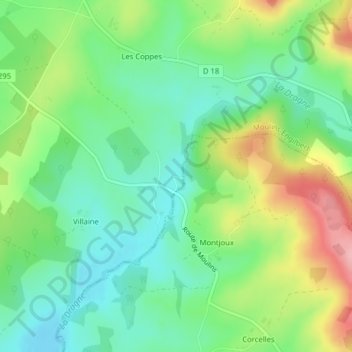
Name: Moulin des Verdelles topographic map, elevation, terrain.
Average elevation: 296 m
Minimum elevation: 245 m
Maximum elevation: 387 m
Other topographic maps
Click on a map to view its topography, its elevation and its terrain.
Les Brasses
France > Bourgogne-Franche-Comté > Moulins-Engilbert
Les Brasses, Moulins-Engilbert, Château-Chinon (Ville), Nièvre, Bourgogne-Franche-Comté, France métropolitaine, 58290, France
Average elevation: 245 m