
Make a donation
Gear up for your next adventure:
As an Amazon Associate, this site earns from qualifying purchases at no extra cost to you.
Tafelbergheide topographic map
Click on the map to display elevation.
Make a donation
Gear up for your next adventure:
As an Amazon Associate, this site earns from qualifying purchases at no extra cost to you.
Tafelbergheide
Het heidegebied kent veel hoogteverschillen, veroorzaakt door het landijs ten tijde van de rissijstijd. Hoogste punt is de Tafelberg waaraan deze heide haar naam heeft te danken. Deze 36,4 meter hoge 'heuvel' is een van de hoogste punten van de provincie Noord-Holland. De naam is ontleend aan een oude oriëntatietafel die zich op deze glooiing bevond. Een deel ervan is nog te bezichtigen in het Museum Hilversum. Bij de renovatie van de Tafelberg in 2019 is een nieuw oriëntatieplateau geplaatst.
Make a donation
Gear up for your next adventure:
As an Amazon Associate, this site earns from qualifying purchases at no extra cost to you.
About this map
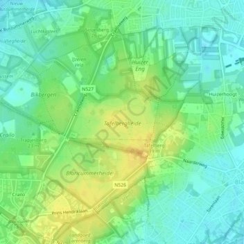
Name: Tafelbergheide topographic map, elevation, terrain.
Location: Tafelbergheide, Huizerhoogt, Huizen, Noord-Holland, Nederland (52.27543 5.21133 52.28277 5.23269)
Average elevation: 16 m
Minimum elevation: 4 m
Maximum elevation: 31 m
Make a donation
Gear up for your next adventure:
As an Amazon Associate, this site earns from qualifying purchases at no extra cost to you.