
Creach Manuel topographic map
Interactive map
Click on the map to display elevation.
About this map
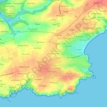
Name: Creach Manuel topographic map, elevation, terrain.
Average elevation: 29 m
Minimum elevation: -6 m
Maximum elevation: 63 m
Other topographic maps
Click on a map to view its topography, its elevation and its terrain.
Pointe Saint-Mathieu
France > Bretagne > Finistère > Plougonvelin > Saint-Mathieu
Pointe Saint-Mathieu, Saint-Mathieu, Plougonvelin, Brest, Finistère, Bretagne, France métropolitaine, 29217, France
Average elevation: 8 m