
Clemmons topographic map
Click on the map to display elevation.
About this map
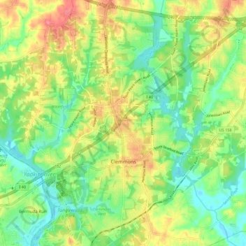
Name: Clemmons topographic map, elevation, terrain.
Average elevation: 235 m
Minimum elevation: 205 m
Maximum elevation: 276 m
Other topographic maps
Click on a map to view its topography, its elevation and its terrain.
Columbia Heights
United States > North Carolina > Forsyth County > Winston-Salem
Average elevation: 260 m
Reynolda Village
United States > North Carolina > Forsyth County > Winston-Salem
Average elevation: 278 m
Reynolda Village
United States > North Carolina > Forsyth County > Winston-Salem
Average elevation: 278 m
Briarcliff Manor
United States > North Carolina > Forsyth County > Winston-Salem
Average elevation: 248 m
West Highlands
United States > North Carolina > Forsyth County > Winston-Salem
Average elevation: 269 m