
Make a donation
Gear up for your next adventure:
As an Amazon Associate, this site earns from qualifying purchases at no extra cost to you.
Basque Country topographic map
Click on the map to display elevation.
Make a donation
Gear up for your next adventure:
As an Amazon Associate, this site earns from qualifying purchases at no extra cost to you.
Basque Country
The Basque Country region is dominated by a warm, humid and wet oceanic climate. The coastal area is part of Green Spain and by extension, the climate is similary for Bayonne and Biarritz as well. Inland areas in Navarre and the southern regions of the autonomous community are transitional, with continental mediterranean climate, with somewhat wider temperature swings between seasons. The list only sources locations in Spain, but Bayonne/Biarritz have a very similar climate to nearby Hondarribia on the Spanish side of the border. The values do not apply to San Sebastián, since its weather station is at a higher elevation than the urban core, where temperatures are higher year-round and similar to those in Bilbao and Hondarribia.
Make a donation
Gear up for your next adventure:
As an Amazon Associate, this site earns from qualifying purchases at no extra cost to you.
About this map
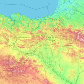
Name: Basque Country topographic map, elevation, terrain.
Location: Basque Country, Spain (41.90989 -3.45035 43.54743 -0.65272)
Average elevation: 560 m
Minimum elevation: -2 m
Maximum elevation: 2,626 m
Make a donation
Gear up for your next adventure:
As an Amazon Associate, this site earns from qualifying purchases at no extra cost to you.
Other topographic maps
Click on a map to view its topography, its elevation and its terrain.
Madrid
Spain > Community of Madrid > Área metropolitana de Madrid y Corredor del Henares > Madrid
Average elevation: 650 m
Huesca
Spain > Aragon > Hoya de Huesca / Plana de Uesca
Huesca lies on a plateau in the northern region of Aragón, with an elevation of 488 m (1,601 ft) above sea level. Close to the city lie the Sierra de Guara mountains, which reach 2,077 m. The geographical coordinates of the city are: 42° 08´ N, 0° 24´ W.
Average elevation: 589 m
Make a donation
Gear up for your next adventure:
As an Amazon Associate, this site earns from qualifying purchases at no extra cost to you.
Soil
Spain > Autonomous Community of the Basque Country > Montaña Alavesa/Arabako Mendialdea
Average elevation: 898 m
Alegranza Island
The area is 10.2 km². The island features a volcano with a crater of about 1.1 km in diameter and an altitude of 289 m. The second highest is Montaña de Lobos at 256 m and following La Rapagura. The northern portion is mainly flat.
Average elevation: 39 m
Make a donation
Gear up for your next adventure:
As an Amazon Associate, this site earns from qualifying purchases at no extra cost to you.
Make a donation
Gear up for your next adventure:
As an Amazon Associate, this site earns from qualifying purchases at no extra cost to you.
Make a donation
Gear up for your next adventure:
As an Amazon Associate, this site earns from qualifying purchases at no extra cost to you.
Mijas
Spain > Andalusia > Costa del Sol Occidental > Mijas > Mijas
The climate changes gradually with increasing elevation in the mountains. Temperatures can drop to 10 °C (50 °F). In the peaks, over 600 m (2,000 ft) high, some ice may form in winter, while precipitation increases to almost 800 mm (32 in).
Average elevation: 447 m
Park Beach
Spain > Andalusia > Costa del Sol Occidental > Estepona > Park Beach
Average elevation: 13 m
Make a donation
Gear up for your next adventure:
As an Amazon Associate, this site earns from qualifying purchases at no extra cost to you.
Caldes d'Estrac
Spain > Catalonia > Maresme > Caldes d'Estrac > Caldes d'Estrac
Average elevation: 57 m
Make a donation
Gear up for your next adventure:
As an Amazon Associate, this site earns from qualifying purchases at no extra cost to you.
Make a donation
Gear up for your next adventure:
As an Amazon Associate, this site earns from qualifying purchases at no extra cost to you.