
Make a donation
Gear up for your next adventure:
As an Amazon Associate, this site earns from qualifying purchases at no extra cost to you.
Spata-Loutsa Municipal Unit topographic map
Click on the map to display elevation.
Make a donation
Gear up for your next adventure:
As an Amazon Associate, this site earns from qualifying purchases at no extra cost to you.
About this map
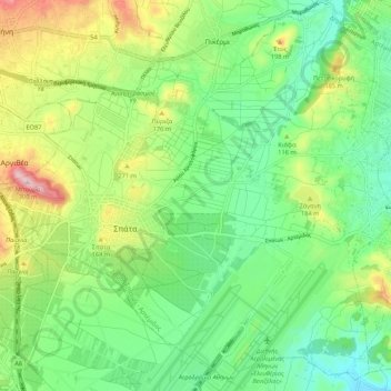
Name: Spata-Loutsa Municipal Unit topographic map, elevation, terrain.
Average elevation: 106 m
Minimum elevation: 9 m
Maximum elevation: 296 m
Make a donation
Gear up for your next adventure:
As an Amazon Associate, this site earns from qualifying purchases at no extra cost to you.
Other topographic maps
Click on a map to view its topography, its elevation and its terrain.
Marathon
Greece > Attica > Regional Unit of East Attica
World records were not officially recognized by the IAAF until 1 January 2004; previously, the best times for the marathon were referred to as the 'world best'. Courses must conform to IAAF standards for a record to be recognized. However, marathon routes still vary greatly in elevation, course, and surface,…
Average elevation: 146 m