
Make a donation
Gear up for your next adventure:
As an Amazon Associate, this site earns from qualifying purchases at no extra cost to you.
Langeac topographic map
Click on the map to display elevation.
Make a donation
Gear up for your next adventure:
As an Amazon Associate, this site earns from qualifying purchases at no extra cost to you.
About this map
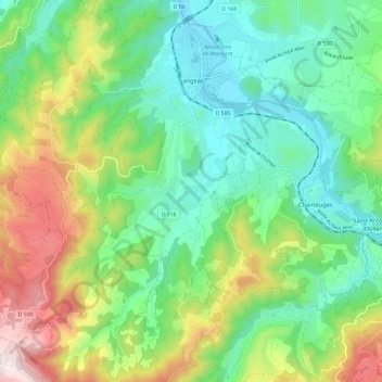
Name: Langeac topographic map, elevation, terrain.
Average elevation: 679 m
Minimum elevation: 486 m
Maximum elevation: 1,078 m
Make a donation
Gear up for your next adventure:
As an Amazon Associate, this site earns from qualifying purchases at no extra cost to you.
Other topographic maps
Click on a map to view its topography, its elevation and its terrain.
Peyredeyre
France > Auvergne-Rhône-Alpes > Haute-Loire > Chaspinhac > Peyredeyre
Average elevation: 739 m
Make a donation
Gear up for your next adventure:
As an Amazon Associate, this site earns from qualifying purchases at no extra cost to you.
Château abbatial
France > Auvergne-Rhône-Alpes > Haute-Loire > Le Monastier-sur-Gazeille > Artaud
Average elevation: 938 m