
Make a donation
Gear up for your next adventure:
As an Amazon Associate, this site earns from qualifying purchases at no extra cost to you.
Gampaha District topographic map
Click on the map to display elevation.
Make a donation
Gear up for your next adventure:
As an Amazon Associate, this site earns from qualifying purchases at no extra cost to you.
About this map
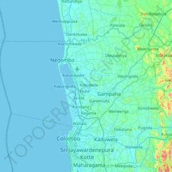
Name: Gampaha District topographic map, elevation, terrain.
Location: Gampaha District, Western Province, Sri Lanka (6.90706 79.61616 7.33053 80.21268)
Average elevation: 25 m
Minimum elevation: 0 m
Maximum elevation: 425 m
Make a donation
Gear up for your next adventure:
As an Amazon Associate, this site earns from qualifying purchases at no extra cost to you.
Other topographic maps
Click on a map to view its topography, its elevation and its terrain.
Make a donation
Gear up for your next adventure:
As an Amazon Associate, this site earns from qualifying purchases at no extra cost to you.
Pahala Millawa North
Sri Lanka > Western Province > Horana DS Division > Pahala Millawa North
Average elevation: 27 m
Make a donation
Gear up for your next adventure:
As an Amazon Associate, this site earns from qualifying purchases at no extra cost to you.