Geolocate

Krok topographic map

Click on the map to display elevation.

About this map

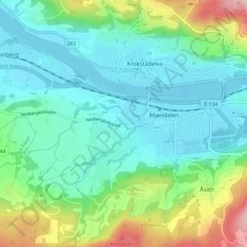
Name: Krok topographic map, elevation, terrain.

Location: Krok, Mjøndalen, Drammen, Viken, 3050, Norway (59.72858 9.97930 59.76858 10.01930)

Average elevation: 70 m

Minimum elevation: -2 m

Maximum elevation: 287 m

Gear up for your next adventure:

🔦Powerful LED Headlamps - Hands-free lighting for night navigation and setting up camp after dark
🧺Fast-Dry Microfiber Towels - Large towels that pack down to the size of an orange
🛠️Outdoor Repair Kits - Gear repair kits
🕶️Polarized Outdoor Sunglasses - Reduce glare from rocks and water for better visual navigation
🎒Hiking Backpacks - Backpacks designed for hiking and trekking

As an Amazon Associate, this site earns from qualifying purchases at no extra cost to you.