
Altındağ topographic map
Interactive map
Click on the map to display elevation.
About this map
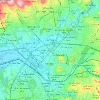
Name: Altındağ topographic map, elevation, terrain.
Location: Altındağ, Ankara, Central Anatolia Region, 06070, Turkey (39.91380 32.81531 39.99380 32.89531)
Average elevation: 904 m
Minimum elevation: 833 m
Maximum elevation: 1,122 m
Other topographic maps
Click on a map to view its topography, its elevation and its terrain.
Gençlik Parkı
Gençlik Parkı, Hacı Bayram Mahallesi, Altındağ, Ankara, Central Anatolia Region, Turkey
Average elevation: 870 m
Su Perileri
Su Perileri, Hacı Bayram Mahallesi, Altındağ, Ankara, Central Anatolia Region, Turkey
Average elevation: 872 m