
Make a donation
Gear up for your next adventure:
As an Amazon Associate, this site earns from qualifying purchases at no extra cost to you.
Price topographic map
Click on the map to display elevation.
Make a donation
Gear up for your next adventure:
As an Amazon Associate, this site earns from qualifying purchases at no extra cost to you.
About this map
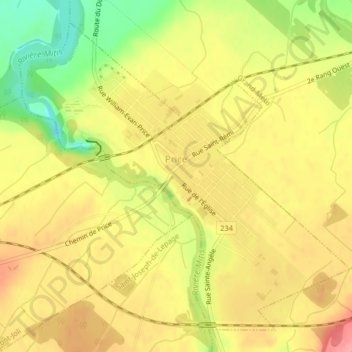
Name: Price topographic map, elevation, terrain.
Location: Price, La Mitis, Bas-Saint-Laurent, Québec, G0J 1Z0, Canada (48.58936 -68.14510 48.61301 -68.10670)
Average elevation: 71 m
Minimum elevation: 15 m
Maximum elevation: 110 m
Make a donation
Gear up for your next adventure:
As an Amazon Associate, this site earns from qualifying purchases at no extra cost to you.
Other topographic maps
Click on a map to view its topography, its elevation and its terrain.
Make a donation
Gear up for your next adventure:
As an Amazon Associate, this site earns from qualifying purchases at no extra cost to you.
Saint-Joseph-de-Lepage
Canada > Québec > La Mitis > Saint-Joseph-de-Lepage > Saint-Joseph-de-Lepage
Average elevation: 115 m
Make a donation
Gear up for your next adventure:
As an Amazon Associate, this site earns from qualifying purchases at no extra cost to you.