
Castañar de Ibor topographic map
Interactive map
Click on the map to display elevation.
About this map
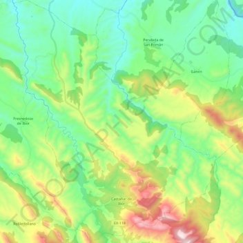
Name: Castañar de Ibor topographic map, elevation, terrain.
Average elevation: 589 m
Minimum elevation: 303 m
Maximum elevation: 1,256 m
Other topographic maps
Click on a map to view its topography, its elevation and its terrain.
Río Ibor
España > Extremadura > Castañar de Ibor
Río Ibor, Castañar de Ibor, Cáceres, Extremadura, 10340, España
Average elevation: 611 m