
Make a donation
Gear up for your next adventure:
As an Amazon Associate, this site earns from qualifying purchases at no extra cost to you.
Quarndon topographic map
Click on the map to display elevation.
Make a donation
Gear up for your next adventure:
As an Amazon Associate, this site earns from qualifying purchases at no extra cost to you.
Quarndon
52°58′8″N 1°29′36″W / 52.96889°N 1.49333°W / 52.96889; -1.49333 This directional compass, provides details of bearings, distances, elevations and dates of nearly 50 places of special interest and was unveiled on 29 September 2001. It stands on an 8-ton block of Derbyshire gritstone – 140 metres above sea level – funded by the will of the third Viscount Scarsdale who died in 2000 aged 76.
Make a donation
Gear up for your next adventure:
As an Amazon Associate, this site earns from qualifying purchases at no extra cost to you.
About this map
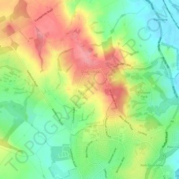
Name: Quarndon topographic map, elevation, terrain.
Location: Quarndon, Amber Valley, Derbyshire, England, United Kingdom (52.94631 -1.52417 52.97845 -1.48333)
Average elevation: 96 m
Minimum elevation: 51 m
Maximum elevation: 149 m
Make a donation
Gear up for your next adventure:
As an Amazon Associate, this site earns from qualifying purchases at no extra cost to you.
Other topographic maps
Click on a map to view its topography, its elevation and its terrain.