Geolocate

Springdale topographic map

Click on the map to display elevation.

About this map
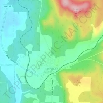
Name: Springdale topographic map, elevation, terrain.

Location: Springdale, Stevens County, Washington, United States (48.04844 -117.75785 48.07768 -117.73607)

Average elevation: 656 m

Minimum elevation: 582 m

Maximum elevation: 818 m

Other topographic maps

Click on a map to view its topography, its elevation and its terrain.

Ford

United States > Washington > Stevens County

Ford is located in a mountainous area at the base of Happy Hill, which rises more than 600 feet immediately to the southeast of the community. The northeast–southwest trending Walkers Prairie and valley floor along which Chamokane Creek flows is relatively flat and at an elevation of between 1,700 and 1,800…

Average elevation: 577 m
Tumtum

United States > Washington > Stevens County

Average elevation: 555 m

Suncrest

United States > Washington > Stevens County

Average elevation: 565 m

Gifford

United States > Washington > Stevens County

Average elevation: 503 m

Grays

United States > Washington > Stevens County

Average elevation: 598 m

Bissel

United States > Washington > Stevens County

Average elevation: 643 m

Enterprise

United States > Washington > Stevens County

Average elevation: 598 m

Wellpinit

United States > Washington > Stevens County

Average elevation: 762 m

Turk

United States > Washington > Stevens County

Average elevation: 949 m

Onion Creek

United States > Washington > Stevens County

Average elevation: 841 m

Rice

United States > Washington > Stevens County

Average elevation: 536 m

Suncrest

United States > Washington > Stevens County

Average elevation: 565 m

Colville

United States > Washington > Stevens County > Colville > Colville

Average elevation: 602 m

Ford

United States > Washington > Stevens County

Ford is located in a mountainous area at the base of Happy Hill, which rises more than 600 feet immediately to the southeast of the community. The northeast–southwest trending Walkers Prairie and valley floor along which Chamokane Creek flows is relatively flat and at an elevation of between 1,700 and 1,800…

Average elevation: 577 m

Velvet

United States > Washington > Stevens County

Average elevation: 814 m

Rocky Butte

United States > Washington > Stevens County

Average elevation: 1,020 m

Calispell Peak

United States > Washington > Stevens County

Average elevation: 1,768 m

Mount Rogers

United States > Washington > Stevens County

Average elevation: 1,437 m

Gear up for your next adventure:

⌚Altimeter Barometer Watches - Outdoor watches with built-in sensors to track altitude changes and weather shifts
🥾Hiking Shoes - Lightweight hiking shoes for day hikes
🛌Compact Down Sleeping Bags - Warmth without the bulk, ideal for backcountry camping
🎒3L Hydration Reservoirs - Hands-free drinking to stay hydrated on steep contour climbs
🕶️Polarized Outdoor Sunglasses - Reduce glare from rocks and water for better visual navigation

As an Amazon Associate, this site earns from qualifying purchases at no extra cost to you.