
Princetown topographic map
Interactive map
Click on the map to display elevation.
About this map
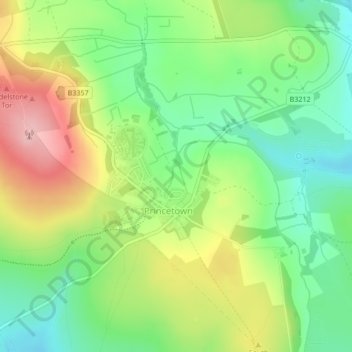
Name: Princetown topographic map, elevation, terrain.
Average elevation: 415 m
Minimum elevation: 347 m
Maximum elevation: 513 m
Princetown, like the rest of Dartmoor, experiences colder and wetter weather than most of Devon, especially because of its high altitude. Snow is uncommon but is usually heavy when it does fall. According to the Köppen climate classification the climate would be classified as Cfb bordering on Cfc.
Other topographic maps
Click on a map to view its topography, its elevation and its terrain.
Tavistock
United Kingdom > England > Devon > West Devon
Tavistock, West Devon, Devon, England, United Kingdom
Average elevation: 139 m
Chagford
United Kingdom > England > Devon > West Devon
Chagford, West Devon, Devon, England, United Kingdom
Average elevation: 309 m