Geolocate

Avon topographic map

Click on the map to display elevation.

Avon

At the 2020 United States Census, the town had a total area of 5,392 acres (21.819 km2) including 48 acres (0.194 km2) of water. The town rests at 7,430 feet (2265 m) elevation.

Wikipedia (CC-BY-SA 3.0)

About this map

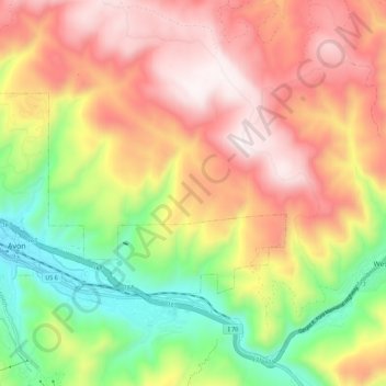
Name: Avon topographic map, elevation, terrain.

Location: Avon, Eagle County, Colorado, 81620, United States (39.62335 -106.55590 39.66822 -106.44437)

Average elevation: 2,620 m

Minimum elevation: 2,222 m

Maximum elevation: 3,219 m

Other topographic maps

Click on a map to view its topography, its elevation and its terrain.

Mount Jackson

United States > Colorado > Eagle County

Average elevation: 3,724 m

Gore Lake

United States > Colorado > Eagle County

Average elevation: 3,548 m

Pitkin Lake

United States > Colorado > Eagle County

Average elevation: 3,542 m

Carterville

United States > Colorado > Eagle County

Average elevation: 2,440 m

Rock Creek

United States > Colorado > Eagle County > McCoy

Average elevation: 2,091 m

Vail

United States > Colorado > Eagle County

Vail's average elevation is 8,150 feet (2484 m) above sea level. The town has a total area of 4.5 square miles (12 km2), with no lakes (there is, however, at least one pond). Gore Creek flows from east to west through the center of town.

Average elevation: 2,953 m

Wolcott

United States > Colorado > Eagle County

Average elevation: 2,239 m

Beaver Creek

United States > Colorado > Eagle County

Average elevation: 2,726 m

Dotsero

United States > Colorado > Eagle County

Average elevation: 2,021 m

Fulford

United States > Colorado > Eagle County

Average elevation: 3,113 m

Suicide Mountain

United States > Colorado > Eagle County

Average elevation: 2,885 m

Beaver Creek

United States > Colorado > Eagle County

Average elevation: 2,604 m

Mount Jackson

United States > Colorado > Eagle County

Average elevation: 3,724 m

Beaver Creek

United States > Colorado > Eagle County

Average elevation: 2,604 m

Wedding Island

United States > Colorado > Eagle County > Vail

Average elevation: 2,808 m

Gear up for your next adventure:

🎒40L Day Hiking Backpacks - Comfortable packs with hydration support for long days exploring topographic peaks
🔪Camping Knives - Multi-purpose outdoor knives
🧯Animal Deterrent Spray - Safety spray for wildlife
🔥Ferrocerium Rod Fire Starters - Reliable fire lighting in wet or windy conditions without matches
👄SPF Lip Balm - Prevent sun and wind-burnt lips on mountain ridges

As an Amazon Associate, this site earns from qualifying purchases at no extra cost to you.