
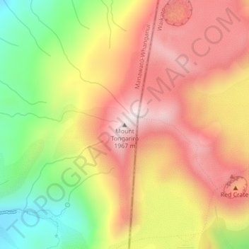
Mount Tongariro topographic map
Interactive map
Click on the map to display elevation.
About this map
Name: Mount Tongariro topographic map, elevation, terrain.
Average elevation: 1,675 m
Minimum elevation: 1,328 m
Maximum elevation: 1,951 m
The high altitude and severe alpine climate between March and October cause snowfall in the winter (there are commercial ski-fields at neighbouring Mount Ruapehu) and rain can freeze, causing verglas; in contrast in the mid to late summer, the mountains can be bare apart from remnant patches of snow in south-facing gullies. Unlike nearby Mt. Ruapehu, no glaciers exist on Tongariro today. However, geomorphological evidence in the form of moraines and cirques indicates the former presence of mountain glaciers. Dating of moraines on western Tongariro show that valley glaciers were present at several times during the last glacial cycle, before melting away at the end of the Last Glacial Maximum approximately 18,000 years ago.
Other topographic maps
Click on a map to view its topography, its elevation and its terrain.
Waiouru
New Zealand > Manawatu-Whanganui > Ruapehu District
Waiouru, Ruapehu District, Manawatū-Whanganui, 4825, New Zealand
Average elevation: 817 m
Whakapapa Island
New Zealand > Manawatu-Whanganui > Ruapehu District
Whakapapa Island, Ruapehu District, Manawatū-Whanganui, New Zealand
Average elevation: 544 m
Tongariro National Park
New Zealand > Manawatu-Whanganui > Ruapehu District
Tongariro National Park, Ruapehu District, Manawatū-Whanganui, New Zealand
Average elevation: 888 m
Erua
New Zealand > Manawatu-Whanganui > Ruapehu District
Erua, Ruapehu District, Manawatū-Whanganui, New Zealand
Average elevation: 845 m
Mount Ruapehu
New Zealand > Manawatu-Whanganui > Ruapehu District
Mount Ruapehu, Ruapehu District, Manawatū-Whanganui, New Zealand
Average elevation: 2,474 m