Geolocate

Golden topographic map

Click on the map to display elevation.

About this map

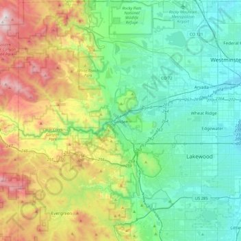
Name: Golden topographic map, elevation, terrain.

Location: Golden, Jefferson County, Colorado, 80401, United States (39.59554 -105.38110 39.91554 -105.06110)

Average elevation: 2,024 m

Minimum elevation: 1,580 m

Maximum elevation: 3,190 m

Gear up for your next adventure:

📍Handheld GPS - GPS devices for hiking and navigation
🔭Compact Hiking Binoculars - Lightweight optics for scouting routes or birdwatching
🧰Survival Kits - Essential survival gear
🚴Bike GPS - GPS devices for cycling
☀️Portable Solar Chargers - High-efficiency panels to hang on your backpack while walking

As an Amazon Associate, this site earns from qualifying purchases at no extra cost to you.