Geolocate

Arnhem topographic map

Click on the map to display elevation.

About this map

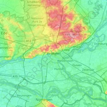
Name: Arnhem topographic map, elevation, terrain.

Location: Arnhem, Gelderland, Netherlands, 6811AL, Netherlands (51.82426 5.75086 52.14426 6.07086)

Average elevation: 24 m

Minimum elevation: 2 m

Maximum elevation: 105 m

Other topographic maps

Click on a map to view its topography, its elevation and its terrain.

Sonsbeek

Netherlands > Gelderland > Arnhem

Average elevation: 43 m

Gear up for your next adventure:

🍳Camping Cookware - Cookware sets for outdoor meals
🦟Insect Repellent - Protection against insects
🧥Insulated Down Jackets - High warmth-to-weight ratio for cold nights in the high country
🪑Portable Backpacking Chairs - A comfortable seat for studying maps at the end of the day
👄SPF Lip Balm - Prevent sun and wind-burnt lips on mountain ridges

As an Amazon Associate, this site earns from qualifying purchases at no extra cost to you.