
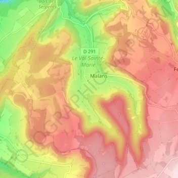
Malans topographic map
Interactive map
Click on the map to display elevation.
About this map
Name: Malans topographic map, elevation, terrain.
Average elevation: 504 m
Minimum elevation: 337 m
Maximum elevation: 628 m
Other topographic maps
Click on a map to view its topography, its elevation and its terrain.
Besançon
Frankreich > Burgund und Freigrafschaft > Doubs > Besançon
Besançon, Doubs, Burgund und Freigrafschaft, Metropolitanes Frankreich, 25000, Frankreich
Average elevation: 332 m