
Make a donation
Gear up for your next adventure:
As an Amazon Associate, this site earns from qualifying purchases at no extra cost to you.
Krupanj topographic map
Click on the map to display elevation.
Make a donation
Gear up for your next adventure:
As an Amazon Associate, this site earns from qualifying purchases at no extra cost to you.
Krupanj
The town lies in western Serbia, at the southern border of the Pannonian plain and Mačva region. It is surrounded by the mountains Jagodnja, Boranja and Sokolska planina, in a valley intersected by several rivers and creeks. In the town itself, the rivers Bogoštica, Čađavica and Kržava conjoin into Likodra, which later empties into Jadar. The town lies at the altitude of 280 m.
Make a donation
Gear up for your next adventure:
As an Amazon Associate, this site earns from qualifying purchases at no extra cost to you.
About this map
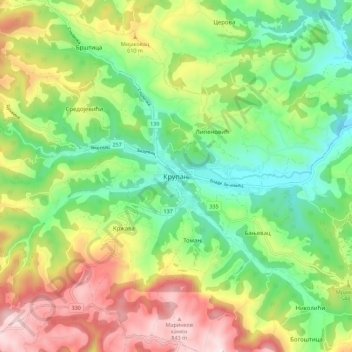
Name: Krupanj topographic map, elevation, terrain.
Average elevation: 484 m
Minimum elevation: 229 m
Maximum elevation: 876 m
Make a donation
Gear up for your next adventure:
As an Amazon Associate, this site earns from qualifying purchases at no extra cost to you.