
Make a donation
Gear up for your next adventure:
As an Amazon Associate, this site earns from qualifying purchases at no extra cost to you.
Mount Warren topographic map
Click on the map to display elevation.
Make a donation
Gear up for your next adventure:
As an Amazon Associate, this site earns from qualifying purchases at no extra cost to you.
About this map
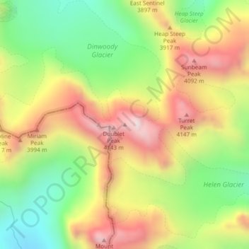
Name: Mount Warren topographic map, elevation, terrain.
Location: Mount Warren, Fremont County, Wyoming, United States (43.16351 -109.62798 43.16361 -109.62788)
Average elevation: 3,738 m
Minimum elevation: 3,338 m
Maximum elevation: 4,177 m
Make a donation
Gear up for your next adventure:
As an Amazon Associate, this site earns from qualifying purchases at no extra cost to you.
Other topographic maps
Click on a map to view its topography, its elevation and its terrain.
Dubois
United States > Wyoming > Fremont County
Dubois is located at 43°32′9″N 109°38′9″W / 43.53583°N 109.63583°W / 43.53583; -109.63583 (43.535936, -109.635915) and an elevation of 2115 m (6940 ft). The Wind River runs through the town.
Average elevation: 2,167 m
Make a donation
Gear up for your next adventure:
As an Amazon Associate, this site earns from qualifying purchases at no extra cost to you.
Make a donation
Gear up for your next adventure:
As an Amazon Associate, this site earns from qualifying purchases at no extra cost to you.
Make a donation
Gear up for your next adventure:
As an Amazon Associate, this site earns from qualifying purchases at no extra cost to you.
Dubois
United States > Wyoming > Fremont County
Dubois is located at 43°32′9″N 109°38′9″W / 43.53583°N 109.63583°W / 43.53583; -109.63583 (43.535936, -109.635915) and an elevation of 2115 m (6940 ft). The Wind River runs through the town.
Average elevation: 2,167 m