
Make a donation
Gear up for your next adventure:
As an Amazon Associate, this site earns from qualifying purchases at no extra cost to you.
Vorderhindelang topographic map
Click on the map to display elevation.
Make a donation
Gear up for your next adventure:
As an Amazon Associate, this site earns from qualifying purchases at no extra cost to you.
About this map
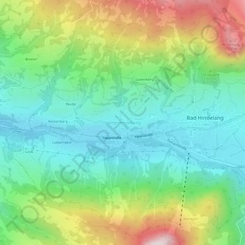
Name: Vorderhindelang topographic map, elevation, terrain.
Average elevation: 1,034 m
Minimum elevation: 772 m
Maximum elevation: 1,565 m
Make a donation
Gear up for your next adventure:
As an Amazon Associate, this site earns from qualifying purchases at no extra cost to you.
Other topographic maps
Click on a map to view its topography, its elevation and its terrain.
Ostrach
Deutschland > Bayern > Landkreis Oberallgäu > Bad Hindelang
Liste der direkten Zuflüsse der Ostrach und ihrer beiden Oberläufe, jeweils von der Quelle bis zur Mündung. Mit Gewässerlänge, Einzugsgebiet und Höhe. Andere Quellen für die Angaben sind vermerkt.
Average elevation: 1,353 m
Hintersteiner Tal
Deutschland > Bayern > Landkreis Oberallgäu > Bad Hindelang
Average elevation: 1,400 m