Geolocate

Karlstad topographic map

Click on the map to display elevation.

About this map
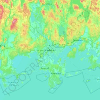
Name: Karlstad topographic map, elevation, terrain.

Location: Karlstad, Karlstads kommun, Värmland County, 652 24, Sweden (59.22091 13.34276 59.54091 13.66276)

Average elevation: 61 m

Minimum elevation: 40 m

Maximum elevation: 165 m

Other topographic maps

Click on a map to view its topography, its elevation and its terrain.

Hammarö kommun

Sweden > Värmland County

Average elevation: 45 m

Årjängs kommun

Sweden > Värmland County

Average elevation: 168 m

Arvika kommun

Sweden > Värmland County

Average elevation: 182 m

Glaskogen

Sweden > Värmland County

Average elevation: 194 m

Torsby kommun

Sweden > Värmland County

Average elevation: 356 m

Hammarö kommun

Sweden > Värmland County

Average elevation: 45 m

Kils kommun

Sweden > Värmland County

Average elevation: 104 m

Säffle kommun

Sweden > Värmland County

Average elevation: 89 m

Hagfors kommun

Sweden > Värmland County

Average elevation: 257 m

Filipstads kommun

Sweden > Värmland County

Average elevation: 241 m

Hammarö kommun

Sweden > Värmland County

Average elevation: 45 m

Storfors kommun

Sweden > Värmland County

Average elevation: 158 m

Pottern

Sweden > Värmland County

Average elevation: 145 m

Karlstads kommun

Sweden > Värmland County

Average elevation: 109 m

Sunne kommun

Sweden > Värmland County

Average elevation: 194 m

Gear up for your next adventure:

🔌Fast Charging Adapters - Quickly top up all your gear before heading back into the field
🎽Hiking Clothing - Breathable clothing for hiking
🧥Down Jackets - Insulated jackets for cold weather
🥾Heavy Duty Hiking Boots - Ankle-supporting boots for carrying heavy packs on steep contours
🔑Heavy Duty Carabiners - Secure gear to the outside of your pack for easy access

As an Amazon Associate, this site earns from qualifying purchases at no extra cost to you.