Geolocate

Fruita topographic map

Click on the map to display elevation.

About this map

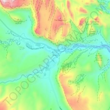
Name: Fruita topographic map, elevation, terrain.

Location: Fruita, Wayne County, Utah, United States (38.26554 -111.26684 38.30554 -111.22684)

Average elevation: 1,803 m

Minimum elevation: 1,621 m

Maximum elevation: 2,111 m

Other topographic maps

Click on a map to view its topography, its elevation and its terrain.

Loa

United States > Utah > Wayne County

Average elevation: 2,158 m

Torrey

United States > Utah > Wayne County

Average elevation: 2,090 m

Teasdale

United States > Utah > Wayne County > Teasdale

Average elevation: 2,197 m

Hanksville

United States > Utah > Wayne County

Average elevation: 1,330 m

Dirty Devil River

United States > Utah > Wayne County

Average elevation: 1,635 m

Gear up for your next adventure:

🖼️Scratch-off Australia Map - Track the regions and peaks you have explored geographically
🦟Insect Repellent - Protection against insects
🧺Fast-Dry Microfiber Towels - Large towels that pack down to the size of an orange
🧭Military Style Lensatic Compass - Durable sighting compasses for advanced land navigation and surveying
🧼Clip-on Hand Sanitizer - Maintain hygiene when water for washing is scarce

As an Amazon Associate, this site earns from qualifying purchases at no extra cost to you.