
Make a donation
Gear up for your next adventure:
As an Amazon Associate, this site earns from qualifying purchases at no extra cost to you.
Scrabo Tower topographic map
Click on the map to display elevation.
Make a donation
Gear up for your next adventure:
As an Amazon Associate, this site earns from qualifying purchases at no extra cost to you.
Scrabo Tower
The tower's style is called Scottish Baronial by most recent authors.: "... mysteriously designed in the Scottish baronial style ..." The article in the Illustrated London News of 1857 says "... in the style of a Scottish chateau ...", whereas the article in the Dublin Builder of 1865 calls it "Scotch baronial". Its height is 135 feet (41 m) as can be confirmed by measuring the scaled elevation drawing in Howley (1993). However, heights of 125 feet and 195 feet have been given.
Make a donation
Gear up for your next adventure:
As an Amazon Associate, this site earns from qualifying purchases at no extra cost to you.
About this map
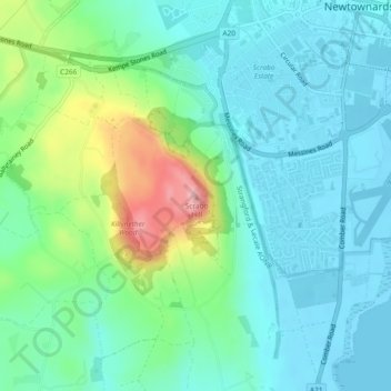
Name: Scrabo Tower topographic map, elevation, terrain.
Average elevation: 39 m
Minimum elevation: -1 m
Maximum elevation: 159 m
Make a donation
Gear up for your next adventure:
As an Amazon Associate, this site earns from qualifying purchases at no extra cost to you.
Other topographic maps
Click on a map to view its topography, its elevation and its terrain.
Ballycullen
United Kingdom > Northern Ireland > County Down > Newtownards > Ballycullen
Average elevation: 49 m