
Thank you for supporting this site ❤️
Make a donation
Make a donation
Gear up for your next adventure:
As an Amazon Associate, this site earns from qualifying purchases at no extra cost to you.
Laimerstadt topographic map
Click on the map to display elevation.
Thank you for supporting this site ❤️
Make a donation
Make a donation
Gear up for your next adventure:
As an Amazon Associate, this site earns from qualifying purchases at no extra cost to you.
Laimerstadt
Das Kirchdorf liegt in den sanft hügeligen Anhöhen des hier beginnenden Jura an der Staatsstraße 2232 etwa 8 km südlich des Altmühltales. Die weiten Ebenen des Donautales befinden sich ca. 10 km südlich des Dorfes.
Thank you for supporting this site ❤️
Make a donation
Make a donation
Gear up for your next adventure:
As an Amazon Associate, this site earns from qualifying purchases at no extra cost to you.
About this map
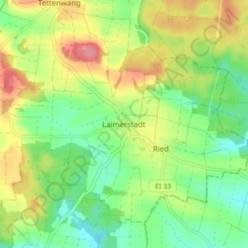
Name: Laimerstadt topographic map, elevation, terrain.
Average elevation: 426 m
Minimum elevation: 390 m
Maximum elevation: 476 m
Thank you for supporting this site ❤️
Make a donation
Make a donation
Gear up for your next adventure:
As an Amazon Associate, this site earns from qualifying purchases at no extra cost to you.