Geolocate

Eudora topographic map

Click on the map to display elevation.

About this map

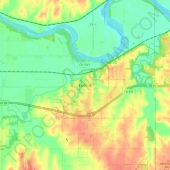
Name: Eudora topographic map, elevation, terrain.

Location: Eudora, Douglas County, Kansas, 66025, United States (38.90334 -95.13858 38.98334 -95.05858)

Average elevation: 258 m

Minimum elevation: 236 m

Maximum elevation: 283 m

👉 Easily get elevation data in JSON, GeoTIFF and KML formats using Elevation API
Thank you for supporting this site ❤️
Make a donation

Gear up for your next adventure:

As an Amazon Associate, this site earns from qualifying purchases at no extra cost to you.

Gear up for your next adventure:

☀️Portable Solar Chargers - High-efficiency panels to hang on your backpack while walking
📍Handheld GPS - GPS devices for hiking and navigation
🖼️Scratch-off Australia Map - Track the regions and peaks you have explored geographically
🌿Flora and Fauna Field Guides - Identify the plants and animals you encounter on your route
🎒Tactical Waist Packs - Quick access to your compass, phone, and snacks while walking

As an Amazon Associate, this site earns from qualifying purchases at no extra cost to you.