Geolocate

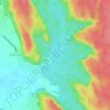
Sector 28 topographic map

Click on the map to display elevation.

About this map

Name: Sector 28 topographic map, elevation, terrain.

Location: Sector 28, Gurgaon, Gurugram, Haryana, India (28.46791 77.07156 28.48148 77.09463)

Average elevation: 243 m

Minimum elevation: 231 m

Maximum elevation: 264 m

Other topographic maps

Click on a map to view its topography, its elevation and its terrain.

Badshahpur

India > Haryana > Gurgaon

Average elevation: 228 m

Damdama Lake

India > Haryana > Gurgaon

Average elevation: 242 m

Gear up for your next adventure:

🔑Heavy Duty Carabiners - Secure gear to the outside of your pack for easy access
🧢Wide Brim Sun Hats - Maximum coverage for the face and neck while out in the open
📍Handheld GPS - GPS devices for hiking and navigation
📚Map Reading & Navigation Guides - Master the art of interpreting topographic contours and symbols
🔦LED Torches - LED torches for outdoor use

As an Amazon Associate, this site earns from qualifying purchases at no extra cost to you.