
Thank you for supporting this site ❤️
Make a donation
Make a donation
Gear up for your next adventure:
As an Amazon Associate, this site earns from qualifying purchases at no extra cost to you.
Saur topographic map
Click on the map to display elevation.
Thank you for supporting this site ❤️
Make a donation
Make a donation
Gear up for your next adventure:
As an Amazon Associate, this site earns from qualifying purchases at no extra cost to you.
About this map
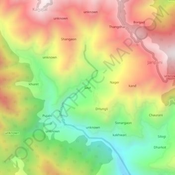
Name: Saur topographic map, elevation, terrain.
Location: Saur, Tehri, Tehri Garhwal, Uttarakhand, India (30.37744 78.31387 30.41744 78.35387)
Average elevation: 1,894 m
Minimum elevation: 1,345 m
Maximum elevation: 2,440 m
Thank you for supporting this site ❤️
Make a donation
Make a donation
Gear up for your next adventure:
As an Amazon Associate, this site earns from qualifying purchases at no extra cost to you.