
Make a donation
Gear up for your next adventure:
As an Amazon Associate, this site earns from qualifying purchases at no extra cost to you.
Gaya Island topographic map
Click on the map to display elevation.
Make a donation
Gear up for your next adventure:
As an Amazon Associate, this site earns from qualifying purchases at no extra cost to you.
Gaya Island
Gaya Island (Malay: Pulau Gaya) is a sizeable Malaysian island of 1,465 ha, just 10 minutes off Kota Kinabalu, Sabah and forms part of the Tunku Abdul Rahman National Park. Gaya Island derived its name from the Bajau word "Gayo" which means big and occupies an area of 15 km² (3,700 acres) with an elevation of up to 300 metres. Several ridges rise more than 600 feet (180 m), peaking at 1,000 feet (300 m), along the backbone of Gaya Island.
Make a donation
Gear up for your next adventure:
As an Amazon Associate, this site earns from qualifying purchases at no extra cost to you.
About this map
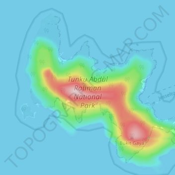
Name: Gaya Island topographic map, elevation, terrain.
Location: Gaya Island, Kota Kinabalu, Sabah, Malaysia (5.99168 116.00487 6.04405 116.06626)
Average elevation: 34 m
Minimum elevation: -1 m
Maximum elevation: 255 m
Make a donation
Gear up for your next adventure:
As an Amazon Associate, this site earns from qualifying purchases at no extra cost to you.