
Make a donation
Gear up for your next adventure:
As an Amazon Associate, this site earns from qualifying purchases at no extra cost to you.
Market Bosworth topographic map
Click on the map to display elevation.
Make a donation
Gear up for your next adventure:
As an Amazon Associate, this site earns from qualifying purchases at no extra cost to you.
About this map
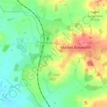
Name: Market Bosworth topographic map, elevation, terrain.
Average elevation: 103 m
Minimum elevation: 78 m
Maximum elevation: 141 m
Make a donation
Gear up for your next adventure:
As an Amazon Associate, this site earns from qualifying purchases at no extra cost to you.
Other topographic maps
Click on a map to view its topography, its elevation and its terrain.
Market Bosworth Country Park
United Kingdom > England > Leicestershire > Hinckley and Bosworth > Market Bosworth
Average elevation: 119 m
Make a donation
Gear up for your next adventure:
As an Amazon Associate, this site earns from qualifying purchases at no extra cost to you.
Ratcliffe Culey
United Kingdom > England > Leicestershire > Hinckley and Bosworth
Average elevation: 77 m
Stretton Baskerville
United Kingdom > England > Leicestershire > Hinckley and Bosworth
Average elevation: 111 m
Fenny Drayton
United Kingdom > England > Leicestershire > Hinckley and Bosworth
Average elevation: 86 m
Make a donation
Gear up for your next adventure:
As an Amazon Associate, this site earns from qualifying purchases at no extra cost to you.
Barton in the Beans
United Kingdom > England > Leicestershire > Hinckley and Bosworth
Average elevation: 113 m
Higham on the Hill
United Kingdom > England > Leicestershire > Hinckley and Bosworth
Average elevation: 96 m
Merry Lees
United Kingdom > England > Leicestershire > Hinckley and Bosworth > Botcheston
Average elevation: 126 m
Make a donation
Gear up for your next adventure:
As an Amazon Associate, this site earns from qualifying purchases at no extra cost to you.
Kirkby Mallory
United Kingdom > England > Leicestershire > Hinckley and Bosworth
Average elevation: 115 m
Make a donation
Gear up for your next adventure:
As an Amazon Associate, this site earns from qualifying purchases at no extra cost to you.
Billa Barra Hill
United Kingdom > England > Leicestershire > Hinckley and Bosworth > Stanton under Bardon
Average elevation: 191 m
Make a donation
Gear up for your next adventure:
As an Amazon Associate, this site earns from qualifying purchases at no extra cost to you.
Burroughs Wood
United Kingdom > England > Leicestershire > Hinckley and Bosworth > Botcheston
Average elevation: 114 m
Sheepy Magna
United Kingdom > England > Leicestershire > Hinckley and Bosworth
Average elevation: 82 m
Make a donation
Gear up for your next adventure:
As an Amazon Associate, this site earns from qualifying purchases at no extra cost to you.
Stanton under Bardon
United Kingdom > England > Leicestershire > Hinckley and Bosworth
Average elevation: 176 m
Stretton Baskerville
United Kingdom > England > Leicestershire > Hinckley and Bosworth
Average elevation: 111 m
Kirkby Mallory
United Kingdom > England > Leicestershire > Hinckley and Bosworth
Average elevation: 115 m
Make a donation
Gear up for your next adventure:
As an Amazon Associate, this site earns from qualifying purchases at no extra cost to you.