
Palma Sola Bay topographic map
Interactive map
Click on the map to display elevation.
About this map
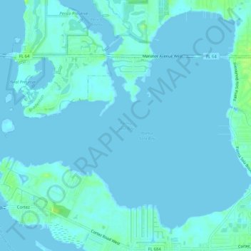
Name: Palma Sola Bay topographic map, elevation, terrain.
Average elevation: 2 m
Minimum elevation: -2 m
Maximum elevation: 12 m
Other topographic maps
Click on a map to view its topography, its elevation and its terrain.
Bradenton
United States > Florida > Manatee County > Bradenton
Bradenton, Manatee County, Florida, 34205, United States
Average elevation: 5 m
Manatee
United States > Florida > Manatee County > Bradenton
Manatee, Bradenton, Manatee County, Florida, 34208, United States
Average elevation: 4 m