
Strawberry Plains topographic map
Interactive map
Click on the map to display elevation.
About this map
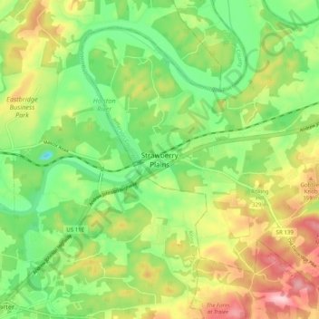
Name: Strawberry Plains topographic map, elevation, terrain.
Average elevation: 298 m
Minimum elevation: 209 m
Maximum elevation: 424 m
Other topographic maps
Click on a map to view its topography, its elevation and its terrain.
Holston River
United States > Tennessee > Jefferson County > Strawberry Plains
Holston River, Strawberry Plains, Jefferson County, East Tennessee, Tennessee, United States
Average elevation: 325 m
New Market
United States > Tennessee > Jefferson County
New Market, Jefferson County, Tennessee, 37820, United States
Average elevation: 352 m
Swann
United States > Tennessee > Jefferson County
Swann, Jefferson County, East Tennessee, Tennessee, 37725, United States
Average elevation: 309 m
Dandridge
United States > Tennessee > Jefferson County
Dandridge, Jefferson County, East Tennessee, Tennessee, United States
Average elevation: 357 m
White Pine
United States > Tennessee > Jefferson County > White Pine
White Pine, Jefferson County, Tennessee, 37890, United States
Average elevation: 351 m
Jefferson City
United States > Tennessee > Jefferson County > Jefferson City
Jefferson City, Jefferson County, Tennessee, United States
Average elevation: 372 m