
Gates of the Arctic topographic map
Interactive map
Click on the map to display elevation.
About this map
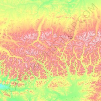
Name: Gates of the Arctic topographic map, elevation, terrain.
Location: Gates of the Arctic, Unorganized Borough, Alaska, VS (67.01944 -156.99942 68.65539 -149.77445)
Average elevation: 663 m
Minimum elevation: 40 m
Maximum elevation: 2,211 m
Other topographic maps
Click on a map to view its topography, its elevation and its terrain.
Denali National Park and Preserve
Denali National Park and Preserve, Denali, Alaska, VS
Average elevation: 777 m
Kenai Fjords National Park
Kenai Fjords National Park, Kenai Peninsula, Alaska, VS
Average elevation: 518 m
Kosciusko Island
Kosciusko Island, Prince of Wales-Hyder, Alaska, VS
Average elevation: 81 m
Glacier Bay National Park
Glacier Bay National Park, Hoonah-Angoon, Alaska, VS
Average elevation: 556 m
Southeast Fairbanks
Verenigde Staten van Amerika > Alaska
Southeast Fairbanks, Verenigde Staten van Amerika
Average elevation: 856 m