
Friemersheim topographic map
Interactive map
Click on the map to display elevation.
About this map
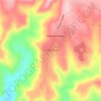
Name: Friemersheim topographic map, elevation, terrain.
Average elevation: 262 m
Minimum elevation: 130 m
Maximum elevation: 343 m
Other topographic maps
Click on a map to view its topography, its elevation and its terrain.
Mossel Bay
South Africa > Western Cape > Garden Route District Municipality > Mossel Bay Local Municipality
To the east, the land slopes upwards towards the wave-cut platform (average elevation 245 metres) that characterises the more lush all-year-round rainfall area of the Garden Route. Here the land is mostly covered by grass and farmlands. The deep sandy soils of the western portion of the municipal area also…
Average elevation: 16 m