
Make a donation
Gear up for your next adventure:
As an Amazon Associate, this site earns from qualifying purchases at no extra cost to you.
Teisbach topographic map
Click on the map to display elevation.
Make a donation
Gear up for your next adventure:
As an Amazon Associate, this site earns from qualifying purchases at no extra cost to you.
Teisbach
Im Topographisch-statistischen Handbuch für den Isarkreis im Königreich Baiern von 1825 ist Teisbach mit 414 Einwohnern in 106 Häusern gelistet. Die zum Markt Teisbach gehörige Exklave Höfen müsste darunter subsumiert sein, da sie nicht separat gelistet ist (innerhalb des Landgerichts Vilsbiburg ist nur das zur Gemeinde Loiching gehörige Höfen gelistet).
Make a donation
Gear up for your next adventure:
As an Amazon Associate, this site earns from qualifying purchases at no extra cost to you.
About this map
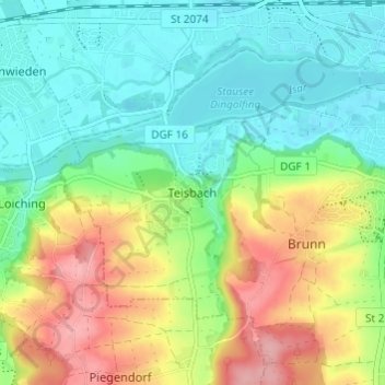
Name: Teisbach topographic map, elevation, terrain.
Average elevation: 398 m
Minimum elevation: 354 m
Maximum elevation: 477 m
Make a donation
Gear up for your next adventure:
As an Amazon Associate, this site earns from qualifying purchases at no extra cost to you.
Other topographic maps
Click on a map to view its topography, its elevation and its terrain.