Geolocate

Libagon topographic map

Click on the map to display elevation.

About this map

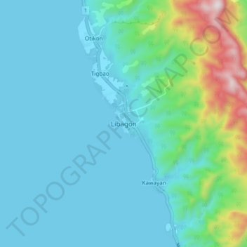
Name: Libagon topographic map, elevation, terrain.

Location: Libagon, Southern Leyte, Eastern Visayas, 6615, Philippines (10.25626 125.01090 10.33626 125.09090)

Average elevation: 140 m

Minimum elevation: 0 m

Maximum elevation: 856 m

Other topographic maps

Click on a map to view its topography, its elevation and its terrain.

Macrohon

Philippines > Southern Leyte

Average elevation: 33 m

Padre Burgos

Philippines > Southern Leyte

Average elevation: 38 m

Thank you for supporting this site ❤️
Make a donation

Gear up for your next adventure:

As an Amazon Associate, this site earns from qualifying purchases at no extra cost to you.

Gear up for your next adventure:

🧦Hiking Socks - Comfortable socks for long hikes
🏃Compression Recovery Socks - Reduce leg fatigue after heavy days of elevation gain
🔑Heavy Duty Carabiners - Secure gear to the outside of your pack for easy access
🧭Compass - Navigation compasses for outdoor exploration
📟Satellite Messengers - Two-way satellite communication to stay in touch beyond the cellular grid

As an Amazon Associate, this site earns from qualifying purchases at no extra cost to you.