
Make a donation
Gear up for your next adventure:
As an Amazon Associate, this site earns from qualifying purchases at no extra cost to you.
Marshall topographic map
Click on the map to display elevation.
Make a donation
Gear up for your next adventure:
As an Amazon Associate, this site earns from qualifying purchases at no extra cost to you.
Marshall
For bicycling, the Ozark Grinder Trail is a nearby gravel grinder bicycle trail covering approximately 200 miles and 13,000 feet of elevation in north central Arkansas Ozarks. The annual Arkansaw High Country Race transits through Marshall each June. This event is an approximately 1,034-mile self-supported (bikepacking) gravel cycling race with approximately 84,000 feet of total elevation.
Make a donation
Gear up for your next adventure:
As an Amazon Associate, this site earns from qualifying purchases at no extra cost to you.
About this map
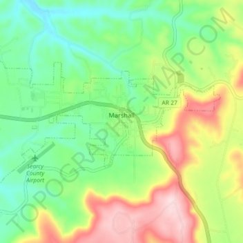
Name: Marshall topographic map, elevation, terrain.
Location: Marshall, Searcy County, Arkansas, 72650, United States (35.89277 -92.67378 35.92193 -92.60221)
Average elevation: 331 m
Minimum elevation: 226 m
Maximum elevation: 503 m
Make a donation
Gear up for your next adventure:
As an Amazon Associate, this site earns from qualifying purchases at no extra cost to you.
Other topographic maps
Click on a map to view its topography, its elevation and its terrain.