
Parkbos-Uilenbroek topographic map
Interactive map
Click on the map to display elevation.
About this map
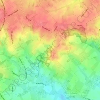
Name: Parkbos-Uilenbroek topographic map, elevation, terrain.
Average elevation: 66 m
Minimum elevation: 30 m
Maximum elevation: 94 m
Other topographic maps
Click on a map to view its topography, its elevation and its terrain.
Hemelveerdegem
België > Vlaanderen > Lierde
Hemelveerdegem, Lierde, Oudenaarde, Oost-Vlaanderen, Vlaanderen, 9571, België
Average elevation: 35 m