
Erraid topographic map
Interactive map
Click on the map to display elevation.
About this map
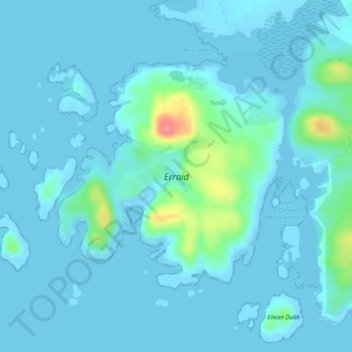
Name: Erraid topographic map, elevation, terrain.
Location: Erraid, Argyll and Bute, Schotland, Verenigd Koninkrijk (56.28387 -6.38584 56.30112 -6.35425)
Average elevation: 8 m
Minimum elevation: -1 m
Maximum elevation: 72 m
Other topographic maps
Click on a map to view its topography, its elevation and its terrain.
North Connel
Verenigd Koninkrijk > Schotland > Argyll and Bute
North Connel, Argyll and Bute, Schotland, PA37 1PL, Verenigd Koninkrijk
Average elevation: 19 m